Bangkok is
sinking
While global warming and the holocaust are still subjects of
academic debate, nobody denies that Bangkok is sinking.
You
can regularly read in the newspaper that Bangkok is sinking and will be under
water in some decades:
Bangkok Is Sinking and May Be Underwater in 15
Years, Study
Says http://www.weather.com/science/environment/news/bangkok-sinking-subsidence-warming-15-years
Is
Bangkok sinking? First a road & now a
footpath
http://www.richardbarrow.com/2012/04/pictures-is-bangkok-sinking-first-a-road-now-a-footpath/
Bangkok
at risk of sinking into the sea Parts of Thailand's capital could be underwater
by 2030 unless the government takes steps to prevent disaster, say
experts
http://www.theguardian.com/environment/2011/sep/06/bangkok-thailand-risks-steadily-sinking
Thailand,
Sinking: Parts of Bangkok Could Be Underwater in
2030 http://content.time.com/time/world/article/0,8599,2084358,00.html
However,
there is one thing I don't understand. If Bangkok is sinking, the soil must be
either compressed (get denser) or move somewhere else. But everywhere around
buildings or pillars for BTS or highway, you see cracks because the surrounding
area is sinking. Why is that? I would expect the heavy buildings or BTS or
highway pillars to sink in. Do their foundations reach solid ground or did the
construction workers not compact the soil after filling construction site holes,
and now it slowly settles? Is the soil all under Bangkok getting dryer or wetter
and shrinks? Here pictures from all over Bangkok.
Pedestrian overpass at
Ramkhamhaeng Soi 60/4:
Ramkhamhaeng
Soi 107 (2 pictures):
MRT
Queen Sirikit Center exit 2:
In Benjakitti Park
สวนเบญจกิติ (just north of QSCNN) as well:
Mor
Chit 2 bus station (2 pictures):
Ekkamai
bus station:
Rama
3 road under expressway in Yannawa (3 pictures),
the road goes
in waves with the peaks at the pillars:
Under
ARL Makkasan (3 pictures):
Particular
bad around highway pillars on Rama 9 near RCA (Royal Castro Avenue entertainment
area, 5 pictures). With level dropping up to 20 cm (vertical, estimated) in the
course of 1 m horizontal, you could think there was an earthquake:
Update: more spectacular
cases at ABAC Suvarnabhumi campus.
The Thais try to outrace
the sinking by putting new layers on roads and sidewalks. I have the impression
that refurbished roads are higher than before. This applies to Soi Goethe and
Soi Than Tawan, that were refurbished in the last years. I have no pictorial
proof, just the impression that the new road level is higher than before. Here
(near Royal Palace) you can clearly see that they put just another layer on
top:
(Similar
in South Pattaya Road intersection with Second Road NW corner.)
And sewer
covers are up to 10 cm below level of sidewalk (probably the sidewalk got a new
layer, but sewer cover remained):
At
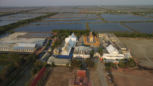
the same time, there is a threat from floods and sea level going inland.
Phanthai Norasing ศาลพันท้ายนรสิงห์ is 5 km inland on maps, but if you look at
in from the air (picture by a friend's drone), it's surrounded by water. Similar
when you look out of the airplane when flying in or out from Suvarnabhumi
airport.
Wat
Khun Samut Chin วัดขุนสมุทรจีน is an even better example of coastline going
inland, but I haven't been yet.
While global warming is
not palpable for the normal citizen (not even for scientists, they have to
analyze data), sinking Bangkok is!
Copyright 2017
ChristianPFC


0 nhận xét